Time: 2012/6 and 2015/10
Place: Alishan town (阿里山) and Shanlinxi town (杉林溪), Nantou
Difficulties: **** (4/5) for the whole trail, **(1.5/5) for section to Shuiyang.
 |
| A-Xi trekking trail 2012 (Photo credit: Monica Liu) |
1. Once upon a trail: Alishan - Xitou
Back to its glory days during 1970s-1980s, a hiking trail had been settled in the woods of Nantou District by Taiwan China Youth Corps . The original trail was in total of 32 km, start from Xitou to Alishan which runs along side of Xitou Giant Trees logging road up to Shanxi highway, Liulongtou, Andingwan, Shanlinxi logging camp, No.9 Trailhead, which later meet up with Mianyue Divine Tree, Shihou (Stone Monkey), Mianyue station, Tashan station and final destination, famous Alishan mountain scenic spot, which called Xi-A vertical trek.
Running along redwoods and cedar, the trail was relaxed and enjoyable. Especially it was featured with several railway stations, which made 32 km seems an acceptable distance. Once, young people used to sit in the train, looked out window for continuous ranges of green forest and enjoyed its fresh pure air. Then they made an easy walk on logging road or good conditioned forest path to the other end of the trail, or pitched a tent elsewhere to stay for one more night in arms of mother nature. Doubtlessly, the trail attracted hundreds of thousands visitors and won a great fame for its name.
Unfortunately, in 1999 Sep 21st a violent earthquake brought not only windy tempest but heavily landslip at many places of the the trail. In consequence, the whole trail was shut down for quite a while, or, should we say, it haven't been opened again since.
Several expedition teams had been sent during those years. However, the route seems a lot shorter than original one, end up at Shanlinxi Recreation park but not Xitou, which total length estimated about 22km. Nevertheless, more scenic spots and optional routes were added in like Thousand People Cave or Fengshan, Shuiyang forest.
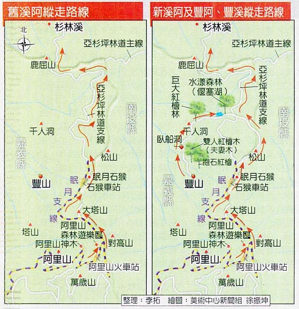 |
| Sketch map of old & new A-Xi Trail (source: keepon.com) |
One of the well-known expeditions was held in Dec 2008 by Shanlinxi Park with a high expectation of reopen the trail again to public. The expedition was participated with a team of ROC Army Aviation and Special Forces Command. Although they successfully reached Xitou after days of trekking from Alishan, a decision of shutting down the trail was made for its high level of difficulty and considered not suitable for poor experience hikers.
In 2011, MIT Taiwan Documentary trekking team also made a professional expedition and filming along, started from Alishan and passed by Shuiyang forest, a new attracted scenic spot formed after 921 earthquake. When the series were released, it recalled quite a memories of local uncles and aunties. A memories of a crowded trail they used to visit 30 years ago.
2. Railway leading to the lost land
At present (2015), the trail is quite a memories for all good, since Forest Service officially banned any practice of trekking the A-xi trail. Contrarily, Shuiyang forest became more and more popular among hikers and visitors.
Years ago, by luck I've joined a 3 days trek with a mt. club. Basically, we had started from Alishan Sister ponds and came accross Tashan intersection, then got along Mianyue railway, passed by Tashan station, camped at Shihou station; second day we headed to Songshan mt., expected a short visit to Mianyue Divine Tree and camped at Shuiyang forest.
Follow up crippled Mianyue line, our trip to the lost trail had begun. The railway Mianyue line had been settled up since 1914, mainly in service of transporting lot of logging wood. The right one is leading to Zhushan, where thousands of tourists expecting Alishan sunrise.
 |
| Left one is Mianyue line, which lead us to a lost trail. Another one may lead you to back to civilization nature area scenic spot. Let's pick one! |
By the way, paradoxically Alishan Mountain Scenic Area contains no mountain named Alishan. Instead, this mountain range is formed by 18 mountains with the famous Zhushan and highest peak Big Tashan (2663m height, known as Tsou aborigines' Divine Mountain). If you're super familiar with the popular folk song The girls from Alishan (阿里山的姑娘Ālǐshān de gūniang), get over it. Honestly, it's a shocking fact for me first time acknowledge there's no mt. named Ali. I felt like my childhood faith had been betrayed. Whatever, let's move on.
Railway Tunnel (明隧道)
After quite a while walking peacefully, the road suddenly ended with the sliding earth slope. No, not just a small slope. It was a giant cliff of falling rocks that had heavily damaged the tunnel in 1999, which was the main reason for the whole train line was shut down ever then.
 |
| Under power of Mother Nature, iron and steel were so helpless. |
 |
| Even safely passed over, I still couldn't believe it. |
This is only one of those obstacles and challenges along the trail. It took our whole team almost 2 hours to safely got over, with assistance of experienced senior in the team. Our journey had just started, and we were exhausted, both mentally and physically.

Later, it turned out there're more tunnels ahead. Luckily, they were not dangerous falling rocks open - cut style tunnels. In contrary, there are classical style of tunnels which matching with the concept of "there's always light at the end of the tunnel."
Tramping along crippled railway through dark tunnels with bright green scenery waiting ahead, should felt like entering an enchanted forest in a fairy tales. Good things did come to those who persevered.
 |
| Way to lost landscape (Photo credit: Yuchia Wang) |
Tashan station
After the tunnel we found Tashan station, once the highest railway station of Taiwan (2346 m height above sea level). Nevertheless, the wooden station now staying quietly in middle of jungle, waiting for a train that would never come back. It became a perfect platform for thru hikers to take a nap and resilient after a long walk from the trail head. Throwing away more than 15kgs of pack was such a release you've ever understand unless bearing it for more than three hours of walking and clearly understand there're still more than 6hrs to expect arrival of camping site.
 |
| Too tired little girl? Let's wait for next train to come or rolling on the railway on your own foot. |
Elevated railway
In those year of 60s, people who sit on the comfortable train looking out the window for breathtaking forest view of Alishan couldn't have been imagined that one day in the future, they have to roll on the elevated railway in middle of the woods on their own feet. The railways was up to 20m height at some points and some run longest to 15-20m from one side to the other end (as my sense of measurement). If you've get acrophobia deep in your blood as I am, then it'd take quite an encouragement and bravery to finish this challenge.
 |
| Exciting elevated railway, 20m from the ground. Ready to hold on your breath? |
You'd like to pray for a bless of sunny days during the hike. For just one shower of rain and the whole railway got a horrible status slippery, and what waiting from 10-20m behind is not a soft and extended grassland like the one in your backyard that you love to roll on. There'd been many trekkers that took best use of their four limbs to get over this sections when it's foggy and raining. Since when your foot slipped away from that 20cm wide wooden board, neither your teammate or a bungee rope could have hold you back.
 |
| Photo credit: Shirley Tsai |
Literally, Shihou means Stone Monkey. Another explanation from very imaginative mind is the stone looks like Dhama practicing meditation. After the falling of Alishan Divine Tree in 1997, Stone Monkey had been promoted as the symbol of Alishan Scenic Area. The next year, officer even had gotten Stone Monkey stamps ready to replace Divine Tree stamp. Paradoxically, two months later, earthquake heavily damaged this new symbol as well as the railway leading to this spot.
 |
| Old days train by Shihou station. Photo credit: internet |
It was a famous and symbolic scenic spot of this area for years. However, after earthquake the monkey lost his stone head and soon face it destiny of being forgotten by crowd of visitors. Which once was a glory, now abandoned in forest; meanwhile, thousand of people still showed up at 10 miles away station - Alishan station. That night, we pitched out tents inside of the wooden station, perfect place to avoid moist atmosphere of foggy rain outside. The trail must be more muddy and slippery in next day, we was afraid of that.
 |
| Photo credit: Camel Hiking Stories |
 |
| A newly collapsed landslide. |
Shigupan Stream (石鼓盤溪)
Shigupan stream is almost the lowest section of this area. From here the trail turned more slippery for thick cover of green mosses everywhere, on the rock, tree roots. I wore a sport shoes, not proper hiking ones. You know that the hiking shoes was costly and as a newbie to trekking, I was not really sure whether to invest in this part. And that costed me 3 days kept regretting and wished that I had bought the right gear for the right activities. I could feel the hardy rock under my feet every step I placed on the trail, and slipped more than ten times. When descending, it was kind of your body was attracted by gravity and there's no way to stop falling down and kissing the ground, sometimes it was too fast that I only realized what had happened when my butts already violently touched the earth.
 |
| Bed of Shigupan Stream, photo credit: Monica Liu. |
On the bright side, this section is extremely refreshing green. I was desperately craving for sunlight shining through the woods and laying its energetic liveliness on those rock. Like, in Ghibli studio's anime. I need that enlightenment so much, but the annoying thick grey clouds above us kept denied my little wish. Like all journey, sometime you've got more than what you expected and another time more upset. Maybe, one day you'd looking back and think: Well, it's not bad. Not bad at all.
 |
| Dense green mosses cover all the rocks. photo credit: Monica Liu. |
Songshan Mt.
Songshan Mt. (2557 m height), is the second highest mountain in Alishan mountainous area. The Mianyue railway was on the left hillside of Songshan mt. We didn't trace along the railway but directly hiked up to the top of mt..
 |
| Photo credit: Monica Liu. |
Being together with those friends in a journey to this lost land, gave me a chance to understand history of this lovely island, as well as its people' attitudes towards nature. The case of Taiwan is a precious lesson for developing countries, where mass logging exploitation is still not an attractive public topic. The unsuitable environmental policies would only stop if the community have the same mutual regards and respect to the natural resources, while at the same time willing to take part in the protecting environment plans. Ironically, we're now staying too far from the woods that can't not hear its crying; until one day a younger generation would walk in and question what did the previous generation do to our forest?
 |
| Have you ever seen a blue light forest? Photo credit: Ann Lee |
Notice the size of those tree trunks, compare with some of the old ones, we easily recognize they had been grown only about 30-50 years ago, in replacement of the exploitation of giant precious timbers of cypress and cedar. The woods is there, telling us the story of the ones came here before: a story of a railway leading to middle of half cut trees juggle; of struggling among civilization, tourism and power of nature.
 |
| Photo credit: Monica Liu |
Opposite with hopeless and grieve for human grease. I'd found endless joy to be with those young people. They acknowledged what was happened in the past and therefore, having a clearer vision as well as smarter choice in future.
Sometimes, it's not about how good is your view on the top of a mountain. It's all about who are you with and those sweaty and happy memories you shared with your companions. Songshan mountain top is the place obviously matches with this journey spirit. We all get tired and exhausted, we all bearing the torture of heavy backpack on shoulders and the slippery road, all the endless up and down and up again. When arrived at top with expectation of an extraordinary view, turns out all we had is... another down-slope waiting to trek before it get dark. Shuiyang senlin is waiting for us.
Sometimes, it's not about how good is your view on the top of a mountain. It's all about who are you with and those sweaty and happy memories you shared with your companions. Songshan mountain top is the place obviously matches with this journey spirit. We all get tired and exhausted, we all bearing the torture of heavy backpack on shoulders and the slippery road, all the endless up and down and up again. When arrived at top with expectation of an extraordinary view, turns out all we had is... another down-slope waiting to trek before it get dark. Shuiyang senlin is waiting for us.
 |
| Songshan mt. top with teammates. Photo credit: Shirley Tsai |
3. The harmony of Water and the Woods (Shuiyang senlin水漾森林)
The interesting attracting place was newly formed after the earthquake in 1999, and rapidly gained great reputation for its stunning view of dead woods reflecting on the water. Let's check the vitality of this white cedar woods in my next post.
The interesting attracting place was newly formed after the earthquake in 1999, and rapidly gained great reputation for its stunning view of dead woods reflecting on the water. Let's check the vitality of this white cedar woods in my next post.
 |
| Misty woods - blue sky and water in the harmony of nature |
References:
I do appreciate those lovely friends (M. Liu, A.Lee and S.Tsai, Y.Wang) who provided me those beautiful photos, that recall a lot of delightful memories and inspiration. Thank you, dears! For purpose of a clearer illustration, I used several online photos, if authors don't approve it, please let me know.
Well written and rich content review Ms.MessyPanda. You've inspired me a lot!
ReplyDeleteKeep trekking!